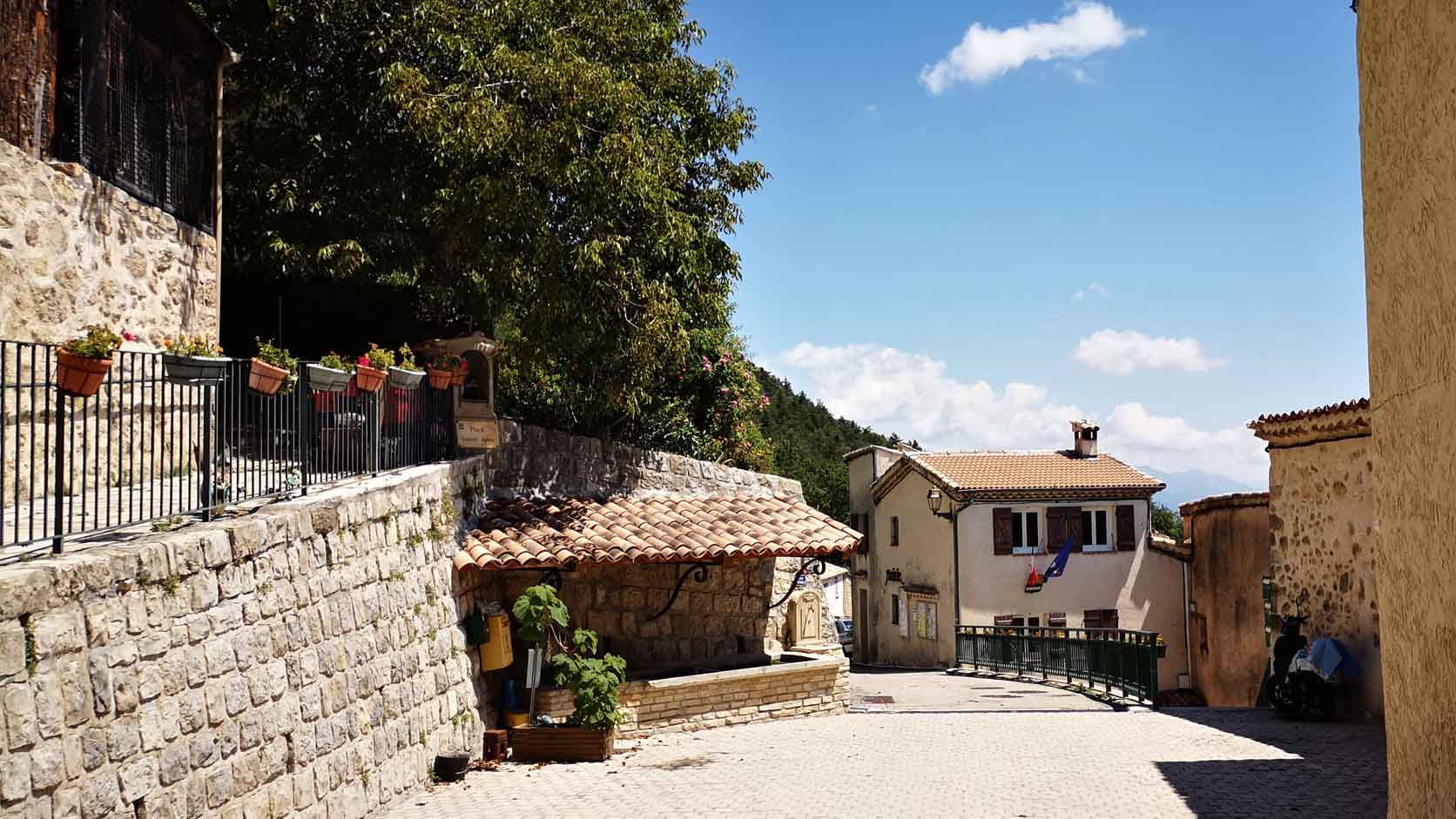
Amirat
Discover the best things to do in Amirat, a peaceful Préalpes d’Azur village at an altitude of 860 meters: Sainte-Anne Church, Saint-Jeannet Chapel, GR4 hiking trails, forests and panoramic views over the Upper Estéron Valley.
Visiting Amirat means discovering a peaceful village in the Alpes-Maritimes, located approximately 860 meters above sea level in the heart of the Préalpes d’Azur Regional Natural Park. Built on the southern slope of a hill, Amirat overlooks the unspoiled landscapes of the Upper Estéron Valley, surrounded by forests, limestone mountains and hiking trails.
If you are looking for the best things to do in Amirat, historic places to see or beautiful hikes around the village, this SAVÙ travel guide will help you plan your visit. Discover Sainte-Anne Church, Saint-Jeannet Chapel, the GR4 trail, the Col du Trébuchet hike and practical advice for exploring this remote corner of the French Riviera hinterland.
Best Things to Do in Amirat
1. Explore the village of Amirat
Amirat is a small rural village in the hills north of Grasse, appreciated for its peaceful atmosphere and natural surroundings. Its houses are arranged along the hillside, overlooking the wooded valleys and mountains of the Upper Estéron.
The center is small and can be explored quickly, but it reveals a very different side of the French Riviera, far from the famous coastal resorts and busy cities. Take time to notice the traditional façades, rooftops, agricultural landscapes and views opening toward the mountains.
SAVÙ tip: Amirat is not a destination filled with tourist attractions, shops or museums. Its appeal lies in its tranquility, rural heritage and surrounding landscapes.
2. Enjoy the view over the Upper Estéron Valley
Amirat’s position on a south-facing hillside provides panoramic views over the Upper Estéron Valley. From the village square and nearby roads, visitors can see a succession of forests, valleys and mountains typical of the Préalpes d’Azur.
In clear weather, some trails above the village also offer distant views of peaks in the Mercantour massif. The light is especially attractive in the morning and toward the end of the day.
3. See Sainte-Anne Church
Sainte-Anne Church is the principal religious building in the present-day village. Its construction is connected with the resettlement of Amirat at the end of the 16th century, after the original medieval settlement located higher on the slopes of the Rocher de Notre-Dame had been abandoned.
The church is notable for its simple appearance and double génoise, an architectural detail formed by rows of curved roof tiles beneath the edge of the roof. The building fits naturally into Amirat’s rural mountain landscape.
Access to the interior may depend on religious services, local events or occasional openings. Even when the church is closed, its exterior and surroundings are worth seeing for the atmosphere and views across the valley.
4. Discover Saint-Jeannet Chapel
Saint-Jeannet Chapel is one of the main historic landmarks in Amirat. Located away from the center, it recalls the traditional organization of the commune, whose population was historically distributed among several small settlements and hamlets.
The chapel stands within an open landscape characteristic of the Préalpes d’Azur. It can be included in a drive through the commune or combined with a walk, depending on your chosen route.
As with many rural chapels, the interior is not necessarily accessible every day. Check whether special openings are organized by the municipality or during national heritage events.
5. Explore the Préalpes d’Azur Regional Natural Park
Amirat is located within the Préalpes d’Azur Regional Natural Park, a protected area of hills and mountains between the Mediterranean coast and the higher Alpine ranges. Its landscapes combine deciduous forests, plateaus, cultivated valleys, limestone cliffs and pastoral areas.
This natural diversity makes the commune an excellent destination for hiking, cycling, mountain biking and landscape photography. The trails cross sparsely populated areas where visitors can enjoy silence and a genuine sense of isolation.
6. Walk along the GR4 trail
The GR4 long-distance hiking trail passes through the territory of Amirat and connects several villages in the Upper Estéron Valley. It follows forest paths and historic routes that once linked remote mountain communities.
Hikers can follow a short section of the GR4 as an out-and-back walk or include Amirat in a longer journey. The route continues toward destinations including Collongues, Les Mujouls and Le Mas.
Before leaving, check a recent map, official trail markers and any current closures. Mobile coverage can be unreliable in the surrounding mountains, so download the route in advance and tell someone where you are going.
7. Hike to the Col du Trébuchet
The Col du Trébuchet circuit is one of the main hikes starting near Amirat. It crosses the extensive forests north of the village before reaching the mountain pass, the rural landscape around Castellet-Saint-Cassien and the beech forest of the Ubac d’Amirat.
This is a full-day hike intended for experienced walkers. The route includes considerable elevation gain, sustained climbs and sections requiring careful navigation. The Alpes-Maritimes Department currently classifies it as a difficult hike.
The circuit reveals several types of landscape, including forests, clearings, mountain passes, agricultural land and distant summit views. Part of the route crosses into the Alpes-de-Haute-Provence department before returning to Amirat.
SAVÙ tip: always check the official Randoxygène information before departure. The recommended route, estimated duration and accessibility may change because of trail conditions, forestry work, weather or wildfire risk.
8. Enjoy the silence and night sky
Amirat is an ideal destination for travelers looking for peace and disconnection. Its distance from major urban areas and low level of development create a particularly quiet atmosphere.
After sunset, limited artificial lighting and the mountain environment generally provide better conditions for observing the night sky than the Mediterranean coast. If you remain after dark, bring a flashlight and drive carefully on the surrounding mountain roads.
The History of Amirat
Amirat is an ancient settlement first mentioned during the 11th century. The original village stood higher on the sunny slopes of the Rocher de Notre-Dame. Conflicts, epidemics and the wider depopulation of the region during the Middle Ages eventually led to its abandonment.
The territory appears to have been entirely deserted around 1400. The present village was established at the end of the 16th century in a more accessible location on the hillside. Sainte-Anne Church is associated with this period of resettlement.
Amirat’s history reflects that of many villages in the French Riviera hinterland: ancient occupation, periods of depopulation and later reconstruction around farming, livestock breeding and forestry.
Today, the paths, religious buildings, hamlets and landscapes shaped by pastoral activity still preserve evidence of this rural history.
Best Hikes Around Amirat
Col du Trébuchet
This forest circuit is the best-known hike starting from Amirat. It reaches the Col du Trébuchet, Castellet-Saint-Cassien and the Ubac d’Amirat. Allow a full day and bring proper hiking shoes, enough water and an offline map.
A walk along the GR4
For a shorter outing, follow part of the GR4 without completing a long circuit. Set a clear turnaround time and adapt the distance to your fitness level, the weather and the elevation gain.
The Upper Estéron Valley circuit
Experienced hikers can include Amirat in a two-day route through the Upper Estéron Valley. The circuit connects several isolated villages, including Le Mas, Gars, Amirat, Collongues and Les Mujouls.
This demanding itinerary requires careful preparation. Check the distances, elevation, accommodation options and current access conditions before departure.
La Maralpine
Amirat is also a stage on La Maralpine, a long-distance route crossing the Préalpes d’Azur. One section connects Amirat with Aiglun through the mountain landscapes of the Estéron Valley.
These routes are intended for hikers with experience in mountainous terrain. Distance alone does not indicate the true difficulty: elevation, heat, forest sections and isolation can make the walk significantly more demanding.
How to Visit Amirat in Half a Day or One Day
Visiting Amirat in half a day
Begin in the center of the village and around Place Sainte-Anne. See the church, enjoy the view over the Upper Estéron and walk along the small roads and paths close to the houses.
Continue toward Saint-Jeannet Chapel if access conditions and your chosen route allow. Half a day is enough to appreciate the village without undertaking a major hike.
Spending one day in Amirat
Arrive in the morning to explore the village and its principal heritage sites at a relaxed pace. Afterwards, choose a hike suited to your experience or follow a short section of the GR4.
Bring a picnic, sufficient water and anything else you may need during the day. Food shops and dining options are very limited in this small mountain village.
A full day for experienced hikers
Well-prepared walkers can devote the day to the Col du Trébuchet circuit. Start early, check the weather and consult the official trail status before leaving the village.
Best Time to Visit Amirat
- Spring generally offers comfortable temperatures for walking, while the surrounding landscapes become green and colorful.
- Summer is suitable for early-morning visits. Always check forest-access restrictions related to wildfire risk before hiking.
- Early fall brings changing colors to the forests and beech woods, while the trails are often quieter.
- Winter offers a peaceful atmosphere, but frost, snow and slippery mountain roads can complicate travel and hiking.
For a combination of village sightseeing, hiking and moderate temperatures, spring and early fall generally provide the best conditions.
How to Get to Amirat
Amirat is located in the Alpes-Maritimes hinterland, north of Grasse and east of Castellane. A car is the most practical way to reach the village and explore the surrounding communities.
From the Mediterranean coast, the journey follows winding mountain roads through several valleys and villages. Distances may appear short on a map, but driving times are longer than in urban areas because of the numerous bends.
Official hiking information indicates parking near the village for the Col du Trébuchet route. Use only designated spaces and never block private access or routes required by emergency vehicles.
Public transportation is very limited in this part of the Upper Estéron. Check all available connections before departure and do not rely on frequent services or last-minute transfers.
Where to Stay and Eat in Amirat
Amirat is a small rural commune, so its tourist facilities are naturally limited. The L’Estelle hikers’ lodge may provide accommodation during certain periods and according to conditions set by the municipality. Contact the property or town hall in advance to confirm availability and make a reservation.
Additional accommodation can be found in other Upper Estéron villages, around Saint-Auban and in the wider Castellane and Puget-Théniers areas. The best choice will depend on your planned route and the direction from which you are traveling.
Restaurants and shops are scarce in the immediate area. For a day trip, bring drinking water, a picnic and basic provisions, while ensuring that you leave no waste behind.
Places to Visit Around Amirat
- Gars: a small village in the Estéron Valley surrounded by mountain landscapes and hiking trails.
- Collongues: an authentic Préalpes village located along several routes through the Upper Estéron.
- Les Mujouls: a hilltop village connected with Amirat by hiking trails and mountain roads.
- Le Mas: a remote mountain commune surrounded by ridges, forests and walking routes.
- Saint-Auban: a village located within a dramatic landscape of cliffs and narrow gorges.
- Briançonnet: a historic village in the hills north of Grasse with a distinctive mountain atmosphere.
- Aiglun: a destination known for its rocky landscapes, gorge and hiking routes in the Estéron Valley.
- Castellane: a convenient base for exploring the Verdon and the villages west of Amirat.
The roads are winding, and travel times can be longer than expected. To enjoy the area properly, choose two or three villages rather than attempting to explore the entire Upper Estéron Valley in one day.
Tips for Visiting Amirat Responsibly
- Stay on marked trails and respect private property.
- Take all rubbish with you and avoid picking wild plants.
- Never light fires or smoke in forested areas.
- During summer, check forest-access regulations before hiking.
- Close pastoral gates after passing through them.
- Do not approach livestock, and remain calm around guardian dogs.
- Carry enough drinking water, as fountains and water sources may not always be available.
- Download your map or hiking route before departure.
Frequently Asked Questions About Amirat
Is Amirat worth visiting?
Yes, especially if you enjoy small mountain villages, rural heritage, panoramic landscapes and hiking. Amirat is primarily a nature and tranquility destination rather than a village with numerous conventional tourist attractions.
How long do you need to visit Amirat?
One or two hours are sufficient for the center and its viewpoints. Allow half a day to add Saint-Jeannet Chapel and a full day if you plan to include a longer hike.
What is the altitude of Amirat?
The present village stands at approximately 860 meters above sea level. The commune extends across higher terrain within the Préalpes d’Azur.
Can you visit Amirat without a car?
It is difficult. Public transportation is limited, and a car remains the most practical way to reach Amirat, carry hiking equipment and explore nearby villages.
What is the best hike in Amirat?
The Col du Trébuchet circuit is the best-known option, but it is long and demanding. For a more accessible outing, choose an out-and-back walk along a marked section of the GR4.
Is the Col du Trébuchet hike difficult?
Yes. It is a full-day mountain hike with considerable elevation gain. It is suitable for experienced walkers with appropriate footwear, sufficient water and reliable navigation.
Where can you park in Amirat?
Parking is available near the village and the starting points of local hikes. Use only authorized spaces and avoid blocking private entrances or emergency access.
Are there restaurants and shops in Amirat?
Options are very limited. Bring water and food with you, and check which shops or restaurants are open in other villages along your route.
Can you visit Amirat with children?
Yes, the village and short walks are suitable for families. However, the Col du Trébuchet circuit requires good endurance and is not appropriate for all children.
What can you do in Amirat for free?
Exploring the village, enjoying the views, seeing Sainte-Anne Church and Saint-Jeannet Chapel, walking along marked trails and discovering the landscapes of the Préalpes d’Azur Regional Natural Park are among the best free things to do in Amirat.
City Gallery